Penzance Maps and Orientation
(Penzance, Cornwall, England, UK)
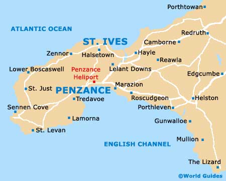
Known for its far western location and close proximity to the famous Land's End area, Penzance is sited within Cornwall's Penwith district, in south-western England. Close to Marazion and sited directly south of St. Ives, the town of Penzance has a population of just over 20,000 people, although this can increase greatly during the summer season, when many visitors arrive in Penzance to soak up the sun and enjoy the sandy beaches scattered around its coastline.
Maps and Orientation of the Town
Known as 'Pensans' by locals in Cornwall, Penzance is a port town and is sheltered from bad weather by Mount's Bay, Cornwall's largest bay, stretching between the Land's End peninsula and the Lizard Point area.
Penzance faces towards the English Channel and is edged on its western side by Newlyn, a small town, which is actually considered to be part of the Penzance parish. Here are the main villages and towns situated nearby Penzance, together with useful distance and journey time information.
- Hayle - 13 km / 8 miles (18 minutes, north-east)
- Helston - 22 km / 14 miles (32 minutes, east)
- Land's End - 15 km / 9 miles (29 minutes, south-west)
- Longrock - 3 km / 2 miles (7 minutes, east)
- Lower Boscaswell - 11 km / 7 miles (26 minutes, north-west)
- Madron - 3 km / 2 miles (8 minutes, north-west)
- Marazion - 6 km / 4 miles (10 minutes, east)
- Mousehole - 5 km / 3 miles (10 minutes, south)
- Penryn - 42 km / 26 miles (58 minutes, east)
- Redruth - 29 km / 18 miles (37 minutes, north-east)
- St. Ives - 16 km / 10 miles (26 minutes, north)
- St. Just - 11 km / 7 miles (25 minutes, west)
- St. Levean - 16 km / 10 miles (34 minutes, south)
- Whitecross - 8 km / 5 miles (10 minutes, north-east)
Map of the United Kingdom

Map of Cornwall

Map of Penzance